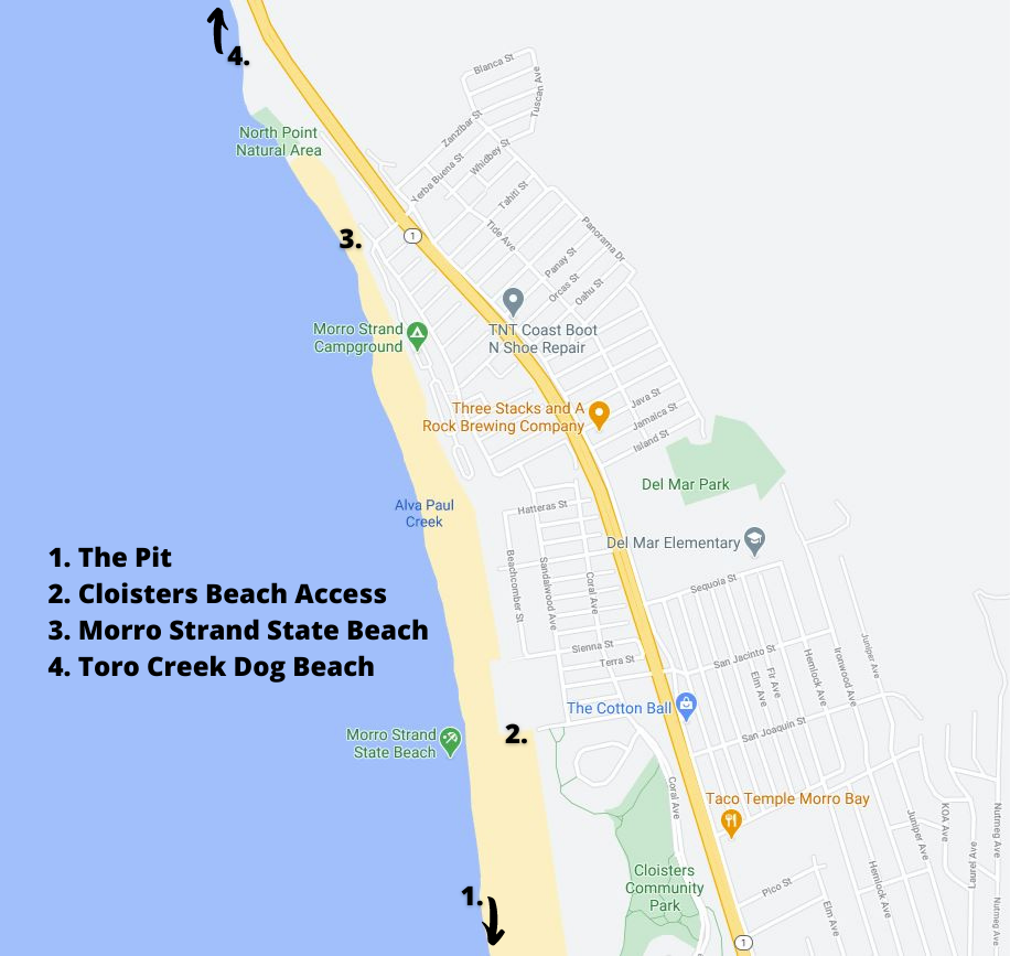
Find your spot along the six miles of continuous sand with this guide to Morro Bay beach access.
The largest and most popular access point to the beach in Morro Bay is at Morro Rock. This large gravel parking lot can fit many cars and is perfect for those who want to watch the surf, visit the otters along the bay, and easily access the sand. However, if you are looking for a spot away from the Embarcadero and a little more off the beaten path, check out these alternative beach access points:

1.) The "Pit" –
The perfect place to explore the sand dunes on your way to and from the ocean, The "Pit" is close to Morro Rock but feels off the beaten path.
Directions: Take the Atascadero Rd exit off HWY 1 and head west. Pass by Morro Bay High School and as the road curves there is a sand parking lot and street parking. Once parked, follow the dune paths to the beach.
2.) Cloisters Beach Access –
This is for those looking for a remote feeling while still being on Morro Bay’s main stretch of stand. Take the beach access from the small parking lot and you’ll emerge mid-way down the beach on a wide stretch of sand.
Directions: Take Highway 1 north to San Jacinto Street. Turn west at the lights and turn left onto Sandalwood Avenue and follow the road until it ends at Azure Street. Make a right turn to the parking lot.
3.) Morro Strand State Beach –
Another great place with sand to spare. And a short walk north from this beach access, is North Point Natural Area (identifiable by the beach stairs) - a great place to go tide pooling.
Directions: Take Yerba Buena Street west off Highway 1 where there is some street parking to access Morro Strand State Beach.
4.) Toro Creek Dog Beach –
This is the spot in town to enjoy the beach with your furry friends. It also tends to be a more active spot of sand with people fishing, jogging, surfing, and walking along the water’s edge.
Directions: Take Highway 1 north from Morro Bay. On your way out of town there are two gravel parking pull-offs on the water side of the highway across from Toro Creek Road.
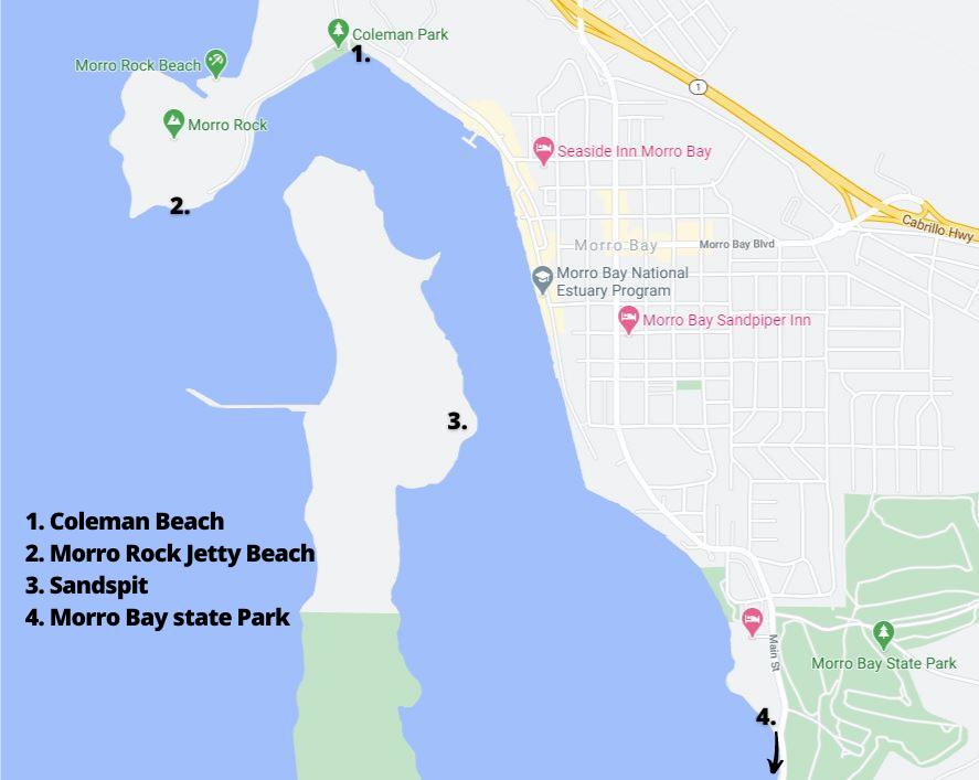
Other beaches to discover in Morro Bay:
1.) Coleman Beach –
The perfect spot to launch the paddleboard/kayak, or to take the kids (the bay keeps this quaint beach sheltered from waves).
Directions: Follow the Embarcadero towards Morro Rock and as the road curves you find Coleman Beach.
2.) Morro Rock Jetty Beach –
This one's off the beaten path, but is perfect for those who want to explore the base of Morro Rock and is a popular surfing spot during large winter swells.
Directions: Follow the Embarcadero towards Morro Rock and continue as the road curves and becomes Coleman Drive. Park along the south side of the parking lot (towards the bay) and walk out towards the jetty where you'll find a small stretch of sand.
3.) Sandspit –
The most secluded of Morro Bay Beaches, the Sandspit is a strip of sand dunes that separates the bay from the ocean. There's lots of room to explore here, but be sure to keep out of fenced off areas to seasonally protect snowy plover nesting.
Directions: Only accessible by water, paddle (paddleboard or kayak) across the protected bay.
4.) Morro Bay State Park –
Further into the bay, this beach is great for water activities, nature encounters, and outdoor exploration. It also offers views of Morro Rock and is a great spot to start your paddle to the Sandspit.
Directions: Drive through Morro Bay State Park along State Park Road. The beach across from Morro Bay Golf Course.